File:Alliances expansive Map.png
From WikiMD's medical encyclopedia
Size of this preview: 800 × 370 pixels. Other resolutions: 320 × 148 pixels | 640 × 296 pixels | 1,357 × 628 pixels.
Original file (1,357 × 628 pixels, file size: 50 KB, MIME type: image/png)

|
File:Large alliances.svg is a vector version of this file. It should be used in place of this PNG file when not inferior.
File:Alliances expansive Map.png → File:Large alliances.svg
For more information, see Help:SVG. |
 |
Transferred from en.wikipedia to Commons by Maksim.
The original description page was here. All following user names refer to en.wikipedia.
Summary
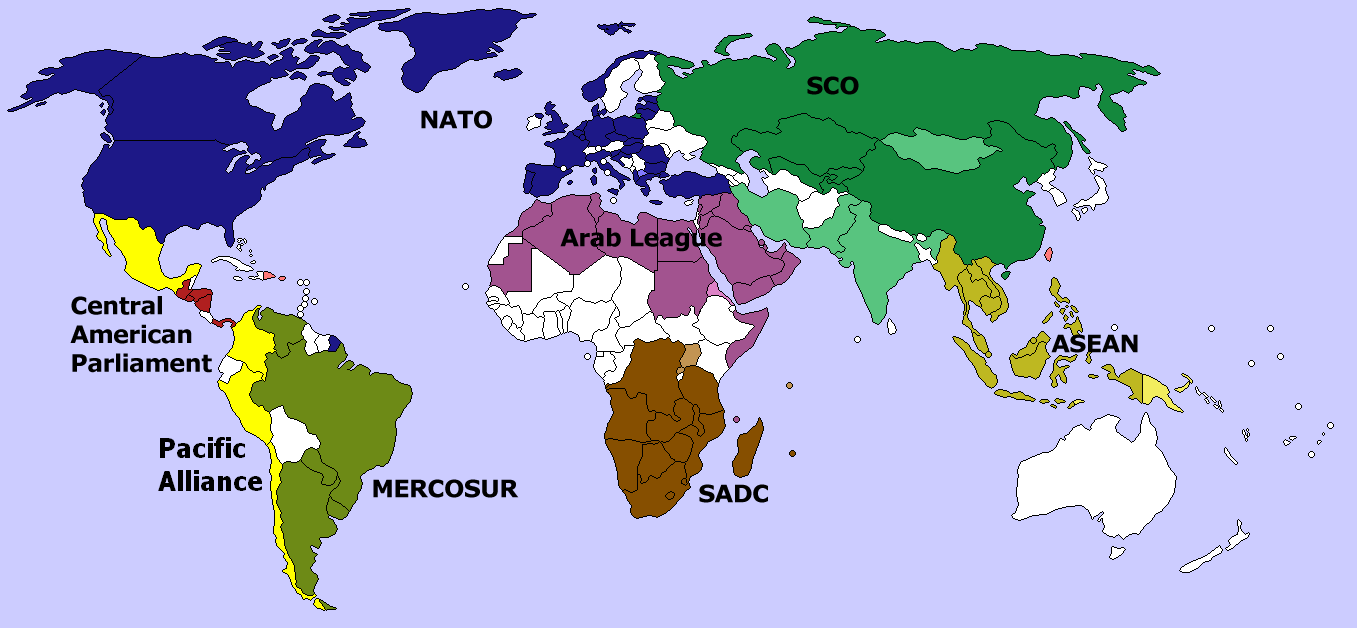
Map of several large international organizations/alliances. Darker colors indicate full membership. Softer colors indicate observer or candidate status. No overlap exists among the organizations shown above. Created by me, using Image:BlankMap-World-v4-colored.png. Aris Katsaris 22:43, 18 March 2006 (UTC)
Licensing
I, the copyright holder of this work, hereby publish it under the following licenses:

|
Permission is granted to copy, distribute and/or modify this document under the terms of the GNU Free Documentation License, Version 1.2 or any later version published by the Free Software Foundation; with no Invariant Sections, no Front-Cover Texts, and no Back-Cover Texts. A copy of the license is included in the section entitled GNU Free Documentation License. |
| This file is licensed under the Creative Commons Attribution-Share Alike 3.0 Unported license. | ||
| ||
| This licensing tag was added to this file as part of the GFDL licensing update. |
You may select the license of your choice.
| date/time | username | edit summary |
|---|---|---|
| 22:43, 18 March 2006 | en:User:Aris Katsaris | (Map of several large international organizations/alliances. Darker colors indicate full membership. Softer colors indicate observer or candidate status. No overlap exists among the organizations shown above. Created by me, using [[:Image:BlankMap-World-v4) |
Original upload log
Legend: (cur) = this is the current file, (del) = delete this old version, (rev) = revert to this old version.
Click on date to download the file or see the image uploaded on that date.
- (del) (cur) 22:43, 18 March 2006 . . en:User:Aris_Katsaris Aris Katsaris ( en:User_talk:Aris_Katsaris Talk) . . 1357x628 (60865 bytes) (Map of several large international organizations/alliances. Darker colors indicate full membership. Softer colors indicate observer or candidate status. No overlap exists among the organizations shown above. Created by me, using [[:Image:BlankMap-World-v4)
File history
Click on a date/time to view the file as it appeared at that time.
| Date/Time | Thumbnail | Dimensions | User | Comment | |
|---|---|---|---|---|---|
| current | 05:09, 4 April 2014 | | 1,357 × 628 (50 KB) | Capmo | addded Pacific Alliance, updated Mercosur |
File usage
The following page uses this file: