File:Koppen-Geiger Map A present.svg
From WikiMD's medical encyclopedia

Size of this PNG preview of this SVG file: 800 × 471 pixels. Other resolutions: 320 × 188 pixels | 640 × 377 pixels | 1,024 × 603 pixels | 1,280 × 754 pixels | 2,560 × 1,507 pixels | 1,401 × 825 pixels.
Original file (SVG file, nominally 1,401 × 825 pixels, file size: 75.4 MB)
Summary
| Description |
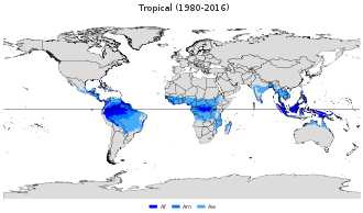
English: Köppen–Geiger climate classification map for Tropical.
tropical rainforest climate
tropical monsoon climate
tropical wet-and-dry / savanna climate العربية: خريطةٌ تصفُ توزيع المناخ الاستوائي (باللون الأزرق) في العالَم |
| Date | |
| Source | "Present and future Köppen-Geiger climate classification maps at 1-km resolution". Nature Scientific Data. DOI:10.1038/sdata.2018.214. |
| Author | Beck, H.E., Zimmermann, N. E., McVicar, T. R., Vergopolan, N., Berg, A., & Wood, E. F. |
| SVG development |

Licensing
This file is licensed under the Creative Commons Attribution 4.0 International license.
- You are free:
- to share – to copy, distribute and transmit the work
- to remix – to adapt the work
- Under the following conditions:
- attribution – You must give appropriate credit, provide a link to the license, and indicate if changes were made. You may do so in any reasonable manner, but not in any way that suggests the licensor endorses you or your use.
File history
Click on a date/time to view the file as it appeared at that time.
| Date/Time | Thumbnail | Dimensions | User | Comment | |
|---|---|---|---|---|---|
| current | 22:58, 7 February 2020 | | 1,401 × 825 (75.4 MB) | Tkarcher | reduced size, +Equator, +German translation (via switch tag) |
File usage
The following page uses this file: