File:Tampa florida map.jpg
From WikiMD's medical encyclopedia

Size of this preview: 492 × 600 pixels. Other resolutions: 197 × 240 pixels | 544 × 663 pixels.
Original file (544 × 663 pixels, file size: 168 KB, MIME type: image/jpeg)
Summary
| Description |
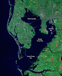
English: Satellite view of Tampa Bay. The raw image was obtained from NASA and/or the US Geological Survey. Post-processing and production by terraprints.com. |
| Date | |
| Source | http://www.terraprints.com |
| Author | terraprints.com |
Licensing
This file is licensed under the Creative Commons Attribution 2.5 Generic license.
- You are free:
- to share – to copy, distribute and transmit the work
- to remix – to adapt the work
- Under the following conditions:
- attribution – You must give appropriate credit, provide a link to the license, and indicate if changes were made. You may do so in any reasonable manner, but not in any way that suggests the licensor endorses you or your use.
File history
Click on a date/time to view the file as it appeared at that time.
| Date/Time | Thumbnail | Dimensions | User | Comment | |
|---|---|---|---|---|---|
| current | 20:22, 5 April 2015 | | 544 × 663 (168 KB) | Zeng8r | Added labels for the named portions of Tampa Bay. |
File usage
The following page uses this file: